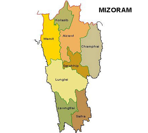
State of Mizoram
Capital: Aizwal
Area: 21,081 sq km
Date of Formation: 20 Feb 1987
Neighboring States: Tripura, Asom, Manipur, Country, Myanmar.
No of Districts: 8, Villages: 707: Towns:22
Legislative Bodie: State Legislature-Unicameral: Assembly Seats: 40 members, Parliament: Lok Sabha seats: 1 (o+o+1), Rajya Sabha Seats:1
Main Political Parties: Mizo National Front, Indian National Congresss, Mizoram People’s Conference, Zoram Nationalist Party, Hmar People’s Convention, Maraland Democratic Front.
Seat of High Court: Guwahati: A bench at Aizawl.
Chief Languages: Mizo, Kuki and English
Major Religions: Christianity
Main Towns: Aizawl, Mamit, Lungle, Lawngtai, Saiha, Chhimtuipui, Saiha
Geography:
(a) Rivers Tlawng (or the Dhaleswari) the Sonal and the Tuivawl
(b) Mountains: Mizoram is a land of hills, the bighest point being the Blue Mountain (2165 metres).
Economy:
(a) Industries: Handloom, rice mills, flour mills, brick making, bamboo handicrafts, sericulture, electronics
(b) Agricultural Products: Maize and paddy. Pulses sugarcane, chilies, banana, ginger, potato, tobacco, vegetables, turmeric and pineapple are the other important crops.
Transport & Communications:
(a) Road Length: 6349km
(b) Main Railway Stations: Bairabi
(c) Airports: Aizawl-Lengpuri.
Culture:
(a) Dances: Bamboo dances, Khantum Solokia, kuallam, Cheraw Kan, Chheiraw and lam. Chheihlam (recount heroics around rice beer) and Khuallam (a dance of guests)
(b) Festivals: Chapchar Kut, Mim Kut (maize fest-Aug-Sept), Pawlkut (harvest-Dec-Jan), Christmas, Easter
(c) Crafts: Puans woven on traditional looms, thi-hi (amber bead necklace), Darhi (glass bead necklace), shawls, cane and bamboo works, Lunglei, Chintapai, Vakiria (headgear).
<< Back to Main List
<< Back to Main List


Post a Comment