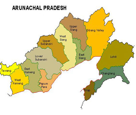
State of Arunachal Pradesh
Capital: Itanagar
Area: 83,743 sq km
Date of Formation: 20 Feb 1987, State: 20 Jan 1972 Union territory created from part of Asom Till 1972, it was known as North East Frontier Agency (NEFA).
Neighbouring States: Asom, Nagaland.
Countries: Bhutan, Myanmar, China.
Population: 1,382,611 Males: 720,232, Females: 662,379, Literacy: 789,943, Males: 454, 532 Females: 335,411 (t66.95% m 73.69% f59.57% ), Sex ration: 920, Density: 17, Decadal growth: 25.92%.
No of Districts:16, Villages: 3,863, Towns: 17
Legislative Bodie: State Legislature-Unicameral, Assembly Seats: 60 (59 reserved for ST), Parliament: Lok Sabha Seats: 2, Rajya Sabha Seats:1.
Main Political Parties: Indian National Congresss, Bharatya Janata Party, Nationalist Congress Party, Arunachal Congress.
Seat of High Court: Guwahati.
Chief Languages: Arunachal Pradesh communities over 50 distinct dialects, mostly of the Sino-Tibetan language family Monpa, Miji Aka, Sherdukpen, Nyishi, Apatani: Tagin, Hill Miri, Adi, Digaru Mismi, ldu-Mishmi, Khamti, Mijiu- Mishmi, Nocte, Tangsa, Wancho.
Major Religions: Hinduismm, Buddhism, Christianity.
Main Towns: Seppa, ltanagar, Dapoorijo, Along, Pasighat, Tezu, Naharlagun, Khonsa, Yingkiong, Anini, Walong, Tawang, Bomdila, Ziro.
Geography:
(a) Rivers: Sirang (name of Brahmaputra), its tributaries- Lohit, Subansiri, Dibang, Kameg, Dikrong River (famous for water sports).
(b) Mountains: Greater Himalaya, Lesser Himalaya, Asom Shiwalik: Dafla Hills, Miri Hills, Mishmi Hills Abor Hills Peaks: Shallum-4336, Ddaphabum- 4578.
(c) Pass Bum La, Tse La, Tunga, Yonggyap Diphu, Kumjawng, Hpungan, Chaukan, Pangasau.
(d) Forest: 60 % of the state.
(e) Wildlife: Namdapha NP, Monling NP, The state’s population is made up of over 26 different tribes and many more sub-tribes.
Economy:
(a) Minerals: Coal (Namchik- Namphuk coal fields), dolomite, marble, lead, Zinc, graphite.
(b) industries: sawmills, plywood (these two trades however have been stopped by law), rice mills, fruit preservation units, handloom and handicrafts.
(c) Agricultural Products: Among the crops grown here are wheat, rice, pulses sugarcane, maize millet, oilseeds and ginger, state of Arunachal padesh is also ideal for horticulture and fruit orchards (Agriculture is the primary driver of the economy. Jhum or shifting cultivation, is widely practiced among the tribal groups) Cash crop like potatoes and hoeticulture crops like apple, oranges and pineapples are getting good promotion.
Transport & Communications:
(a) Main Railway Stations: Bhalukpong
(b) Airports: ltanagar, Daparjio. Ziro, Along, Tezu, Pashigat.
Shopping: Bags, Sherdukpan shawls, Handicrafts, jackets are very popular.
Culture: (a) Dances: Hiiri khaning, Popir, Cham, Aji Lama. War dance: (b) Festivals, Mopin, Solung, Lossar, Booriboot, Sherdukpen, Si-Donyi, Nyokum, Dree, Reh, Chalo-loku.
<< Back to Main List
<< Back to Main List


Post a Comment